Monday, February 11, 2013
Final GIS Maps
The map above displays large majority of Muncie, Indiana. For this map a chose to show my site with a saturated orange / yellow polygon. Other feature that I chose to display were Recreational Facilities, Schools, Trails, Railroads, Roads, Highways, Floodplains, and Wetlands. I used various colors for the transportation (roads, highways, trails, and railroads) to create the hierarchy of transportation throughout Muncie.
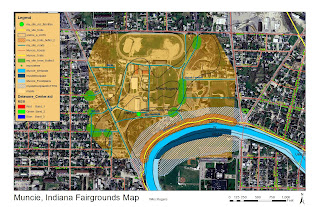
This map displays my site as a closer level for more detailed viewing. Transportation feature that I displayed in this map include trails (with buffer) and roadways. I also included the trees that are located on the site and included a buffer around them. Next I displayed the White River floodplain with buffer on my site. The buffer around objects helps later in the design process to help us understand what should be "left alone" or items that need consideration. Lastly I added in the soil conditions into the site. This helps establish an idea of what can be created on top of the soils listed for this site.
Subscribe to:
Post Comments (Atom)


Wes, these posts are looking great! Keep up the good work...
ReplyDelete